
The stretch of South Highland Road in Putnam Valley that the Appalachian Trail crosses doesn’t look too different from the rest of the road as you zoom past in your car. But when I recently walked the patch of road with Cory Tiger of the Hudson Highlands Land Trust, I began to see it in a different light.
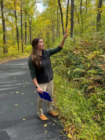
Using a worksheet created by an initiative called Follow the Forest, Tiger showed me how unusually favorable this short stretch is for wildlife crossings.
There were no guardrails to slow down deer, no 90-degree curbs to stop newts. The trees on either side of the road are tall enough to form an interlocking canopy, which is handy if you’re a flying squirrel whose habitat range is drifting north because of climate change and you need a safer way to cross the street. Even the harmful invasive plants such as barberry, knotweed and tree of heaven that filled the rest of the street were absent here, making it more enticing to native wildlife.
There is also what lay beyond our vision. The north side of the street was a 1,439-acre protected section of Fahnestock State Park with no roads running through it. The south side consisted of 400 protected acres surrounding the Appalachian Trail.
The parcels are what Follow the Forest considers “core forests,” and the section of road is a potential habitat linkage. But without enough features to facilitate safe wildlife crossings, it could be potentially deadly for animals as well as the humans who hit them with their cars.
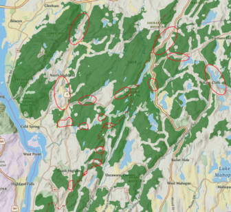
In the western U.S., the features include multimillion-dollar, grass-covered bridges over highways. In the Highlands, the interventions would probably be far more modest: gaps in fences, slanted curbs, conservation easements, planting of native species. Follow the Forest has selected hundreds of potential habitat linkages in the Northeast, stretching from the Bear Mountain Bridge into Canada, which can be found on an interactive map at bit.ly/FTF-hudson, but each needs to be examined in person.
That’s where local residents come in. The Hudson Highlands Land Trust is partnering with the Housatonic Valley Association (HVA) to host a community science workshop in Garrison on Friday (Oct. 27) to train people to assess potential linkages. (Register at bit.ly/FTFworkshop.)
“We can only gain so much information from behind our computers,” says Julia Rogers of HVA. “It’s the people in our communities who are driving the roads every day that see the wildlife patterns.”
Rogers worked for the land trust before joining HVA in 2021. The two nonprofits have a similar mission: Protect large parcels and find ways to connect them. The larger the parcel, the more drinking water it can filter, the more resilient it can be to climate change and the easier it becomes for wildlife to move around. But climate change is increasing migration as former habitat areas become inhospitable and wildlife must hit the road to find new homes.
It’s also changing migration in surprising ways. Decades ago, the Hudson River froze solid, allowing people to walk between West Point and the Highlands. What sort of animals made that crossing? What are they doing now instead?
Since every land trust covers only so much ground, HVA developed Follow the Forest for conservation groups in the Northeast to work together. Connecting the core forests through linkages not only prioritizes what parcels should be protected but identifies where it makes the most sense to build housing, roads and other infrastructure.
“How do we as communities fit within this bigger picture?” Rogers asks. “We tend to think of ourselves as separated, yet we are influencing these ecosystems.”
The project is also an act of interspecies empathy. How would you cross the road you live on if you were a fox or a salamander? What would make it safer?
These potential connections and their obstacles became all too clear to me the day after I spoke with Tiger and Rogers when, as I drove on Red Schoolhouse Road at dusk, a bobcat darted in front of me, missing my car by a whisker. It was the first bobcat I’ve seen in 16 years of living in the Highlands, and I almost ran it over.
When I got home, I went to the Follow the Forest map online and zoomed in on the spot where the encounter took place. The bobcat had been running from the Muller Pond trail to the Sierra Trail. I knew those trails well, but as the map confirmed, neither the meadows surrounding Muller Pond nor the woods surrounding Sierra Pond were anywhere near large enough to be a core forest.
Zooming out, I looked at the intertwined network of dense roads and how far they were from a landscape that wildlife might consider safe. I thought about how many roads that bobcat still had to cross as it headed north. Would its luck run out?
