
Water levels expected to rise 4 feet in Cold Spring by 2080
By Michael Turton
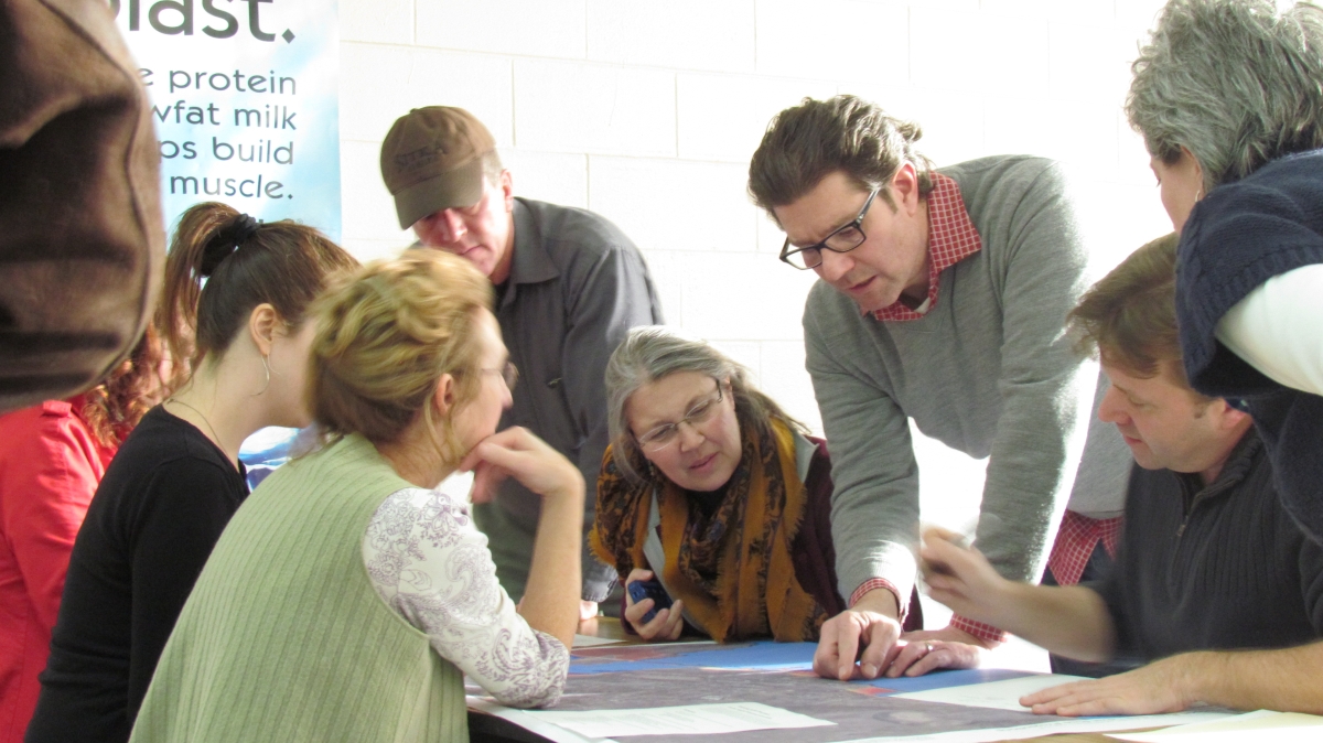
Climate change is often discussed on a global scale, but it took on a sense of urgency at the most local level — the Village of Cold Spring — at a public forum held in the music room at Haldane on Saturday, Jan. 18. Hurricanes and High Water brought together more than 40 residents, who first heard from a representative of the New York Department of Environmental Conservation (DEC) regarding how climate change is likely to affect the village and what can be done about it on a broad scale, before beginning the task of identifying local problems and potential solutions.
Rising waters
Kristin Marcell, special projects coordinator of the Hudson River Estuary Program, a partnership between the DEC and CornellUniversity, gave a rather dire summary of what is happening to climate in the HudsonValley. The most startling statistic she offered is a predicted 4-foot rise in water levels at Cold Spring by 2080 — just 63 years from now.
Marcell said that the number of storms that have produced more than an inch of rainfall increased by 74 percent between 1958 and 2010. The increase in intense rainfall events is expected to continue. The 100-year storm — a weather event severe enough that there is only a 1 percent probability of it occurring at any given time — is also changing.
While that storm used to produce 5.5 inches of rain, it is now calculated to produce 7 inches of rainfall. A storm producing 5.5 inches of rain is now considered the 66-year storm, meaning it is that much more likely to occur than in the past. In addition, winter rainfall will increase while summer rainfall will decrease. Excessive heat is expected in summer months and short-term droughts are also predicted.
Michael Armstrong, chair of the Special Board for the Comprehensive Plan/Local Waterfront Revitalization Plan (LWRP), said that the purpose of the meeting was to “get community input … share and gather information regarding resources and possible strategies.”
The Waterfront Plan
The DEC is encouraging communities to take a serious look at climate change and especially how to address the challenges it presents. Communities that agree to take a pledge and meet a number of basic, action-based initiatives can be designated a “Climate Smart Community” and with that receive free technical advice from leading experts as they plan their strategies.

For Cold Spring, the timing is good. Armstrong said that a draft LWRP will be complete by May. It will include policies and recommendations for shoreline management and related topics.
The Special Board is in the midst of drafting policies now, including those dealing with flooding. He said information gathered at Saturday’s meeting will be incorporated in the LWRP’s policies and, while another forum focusing on climate change and rising water levels will not likely take place, those issues will be addressed at the twice-monthly LWRP meetings, which are open to the public.
Once the LWRP is accepted by the Cold Spring Village Board, it will undergo extensive review, including SEQRA and by state and federal agencies. When final approval is given, the LWRP will have legal standing at all levels of government, and local laws will be required to comply with its policies.
The plan will give the village the ability to adopt laws regarding shoreline use, and Armstrong said that having an LWRP could pay dividends to Cold Spring in the form of government grants as it develops its strategies for managing the shoreline in the face of climate change. He said that Dobbs Ferry, a downriver community with a completed LWRP, recently received $6 million dollars in grants for its waterfront initiatives.
Shoreline treatment
Marcell highlighted a number of solutions adopted elsewhere that Cold Spring may consider. She said that New York Gov. Andrew Cuomo is stressing the use of “green infrastructure” in shoreline management — approaches that incorporate the use of more cost-effective, vegetative-based solutions and less rigid designs than in traditional treatments, which often used costly, hard metal surfaces and straight-line designs.
Upriver at Esopus Meadows, a shoreline treatment utilizing green solutions withstood both Hurricane Irene and Hurricane Sandy. At BrooklynBridgePark, a wetland was constructed as part of shoreline protection. In Tarrytown, at the former General Motors Co. property, a greenway was created at the water’s edge incorporating buffer areas and trails. In other locales, zoning has been used to control development in 100-year floodplain areas. And in Hamburg, Germany, an area of the city was designed to intentionally allow flood waters to temporarily inundate streets and the first floor of buildings, allowing life to go on as normal on the higher floors until flood waters recede.
A plus for Cold Spring is that DocksidePark and FoundryPark have been recently chosen as demonstration sites as part of a partnership among the National Oceanic and Atmospheric Administration, Hudson River National Estuarine Research Reserve and the DEC. The sites will be used to show how green infrastructure can be incorporated into shoreline management. Commenting on the selection of the two parks as demonstration sites, Special Board Vice Chair Anne Impellizzeri said, “We are very privileged,” to which Marcell added, “And it’s on the state’s dime.” The Demonstration Site Network Program will pay project costs.
Discussing solutions
Marcell encouraged Cold Spring residents to address key questions about its waterfront in light of the climate change that is taking place: What is the lifespan of the infrastructure? What is the long-term vision for a waterfront plan? What assets need to be conserved? Is there a strategy for moving certain resources if necessary? In finding solutions that make sense for Cold Spring, Marcell said that key riverfront assets need to be identified and prioritized along with the risks that threaten them.
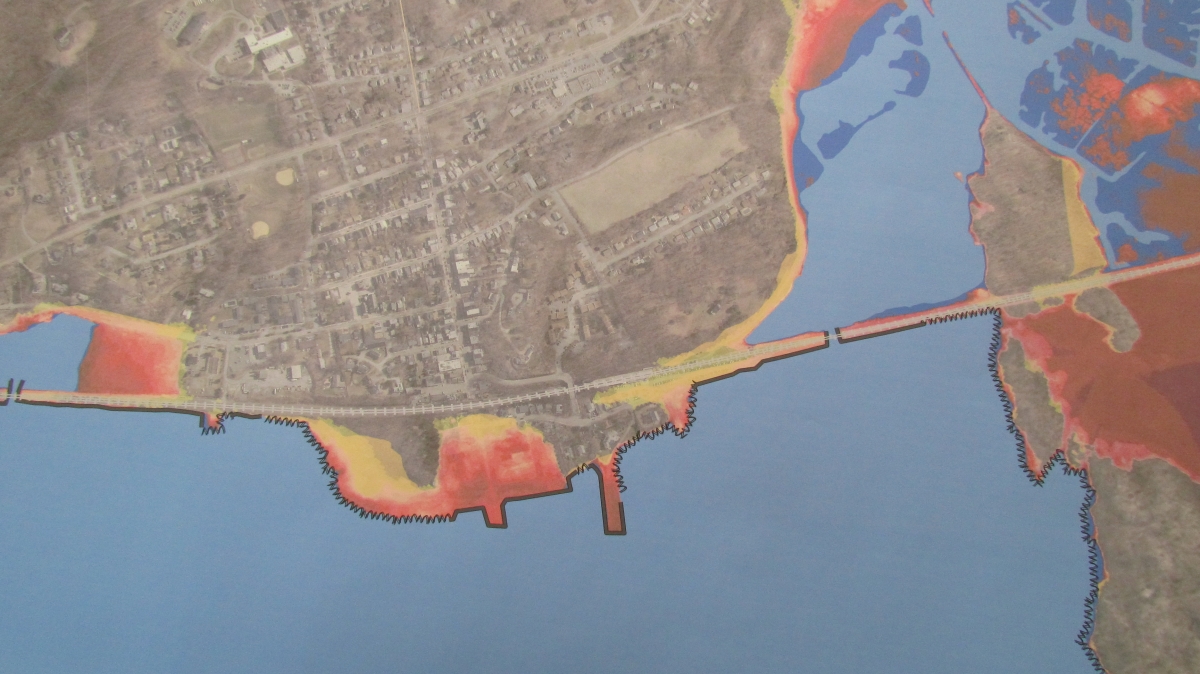
Participants broke into three groups to begin the process of identifying key assets along the Cold Spring waterfront, challenges and possible solutions. Maps recently produced by Scenic Hudson that show the projected rise in river levels were used as part of the exercise. Key assets identified included businesses and residences in the area of lower Main Street, the sewage treatment plant and pumping station, and the bridge, which provides the only access point to the riverfront.
The Metro-North tracks were underlined as a resource of vital importance to commuters and tourism, although some expressed concern that the railway company is not doing enough planning regarding such issues as the effect of rising water levels on the tracks.
Solutions discussed included dredging the marshes south of the village in order to increase their water storage, while using the fill to increase the elevation of properties such as Dockside. Cold Spring’s Water and Wastewater Superintendent Greg Phillips was not able to attend but provided a detailed memo analyzing the situation and possible approaches regarding the sewage treatment plant and pumping station.
Severe storms, flooding, power outages and other weather-related disruptions have increased in frequency in recent years. Residents near the waterfront experienced severe flooding from the river during Hurricane Sandy and others from inland streams during Hurricane Irene. “It’s clearly not an abstraction,” Armstrong said.
In summing up, he cited the pumping station on West Street, which lies in the flood zone and is worth tens of thousands of dollars, emphasizing the need to stabilize the shoreline at Dockside and to more effectively manage storm-water runoff that flows down from the village to the riverfront.
During one of the discussion groups, a participant suggested that one possible solution might be to move residences out from below the railroad tracks to other locations while creating a marina on the riverfront.
Rita Seibel who lives close to the riverfront responded emotionally. “Please don’t underestimate that our homes are there. It’s easy to say relocate, but I don’t want to lose my home.”

Thank you for the excellent report on the Special Board’s Hurricanes and High Water Workshop. What I most appreciate about the lively comments and active participation of residents at the workshop was the “can-do” spirit. No doubt about it, climate change poses daunting challenges for Cold Spring. To see those challenges clearly, and to think through tough, practical solutions, will take optimism and the faith that this community can and will think and act wisely, and effectively.
Special thanks to Scenic Hudson’s Sacha Spector for the LIDAR maps that wowed us all, and to Kristin Marcell of the DEC with that amazing presentation and the photo simulations showing Cold Spring’s shoreline in 2080.