
Dutchess identifies areas made vulnerable by climate change
Few Beacon residents need a report from Dutchess County to tell them the parking lot at the train station is at risk of flooding.
Over the past few months, the riverside half has flooded regularly. Many residents recall the underpass being submerged during Hurricane Irene in 2011 and Superstorm Sandy in 2012.
Beacon’s two connections to Interstate 84 are also vulnerable, and rains could cause landslides that impact the intersection of Route 52 and I-84.
These are a few of the findings in a report released last week by the Dutchess County Transportation Council as part of a project to identify and address climate change’s impact on the county transportation system. The project included creating an interactive map at gis.dutchessny.gov/resilient-ways-forward that shows which roads, bridges and public transportation systems are most at risk of flooding and landslides.
Wedged between a river and a mountain and bisected by a creek, Beacon has no shortage of vulnerabilities.
The eastern edge of Main Street, past the intersection of Verplanck Avenue, is particularly at risk because it runs alongside Fishkill Creek before the water reaches the falls and drops to below street level.
The map warns that neighboring Ackerman Street, Herbert Street and Blackburn Avenue are at high risk for floods and that Beacon residents shouldn’t be surprised if Dennings Point temporarily becomes Dennings Island after a storm. Many streets in downtown Fishkill are also rated as highly vulnerable to flooding.
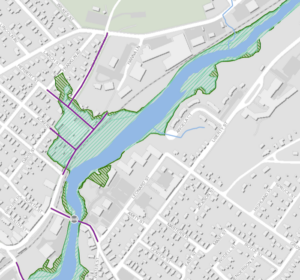
In addition, many neighborhoods near Mount Beacon and the Fishkill Ridge have a “very high” susceptibility to landslides. These include the stretch of Howland Avenue after it separates from Route 9D near the Mount Beacon parking lot, East Main Street after it branches off from Washington Avenue and climbs toward the mountain, and the southernmost edge of Glenham.
The Transportation Council also examined the potential effects of snow, wind, drought and extreme heat. As global temperatures rise, the county’s sidewalks and network of rail trails could become unusable during the summer as the paved surfaces retain heat. Rising temperatures will mean less snow in the Hudson Valley, but blizzards will still occur, slowing down buses and motorists.
The project’s next phase will identify possible responses by municipalities and private landowners, such as an increase in shade trees along rail trails and sidewalks, more vegetation alongside streams near roads and bridges to mitigate flooding, permeable pavers that absorb water, heated bus shelters, retaining walls to fortify slopes and redirecting roads away from areas prone to landslides.
“We’re trying to provide data, resources analysis and possible adaptation measures to agencies so they can implement them either holistically or on a case-by-case basis,” said Mark Debald of the Transportation Council, although most highway departments in the county are already aware of the project.
Debald said the project can help direct federal grant money, particularly from the 2021 Bipartisan Infrastructure Law, to offset climate change. “It would require hundreds of millions of dollars for the county to become fully resilient,” he said. “We know that’s not possible. That’s why we need to prioritize improvements, and this is a positive step in that direction.”

Once again The Current doesn’t (or purposely won’t) take the next step and investigate what impact climate change and rising river levels will have on the proposed Fjord Trail boardwalk. A simple checking of the Hudson River Sea Level Rise option on the Dutchess County website referenced in this article reveals that by 2050, a large portion of the proposed trail route along the river would be inundated and by 2080 it would be a sunken relic along with the MTA tracks. Are the planners over at HHFT denialists?
The Fjord Trail claims in its master plan (page 98) that the design will accommodate sea-level rise. Further reading:
A New Route for Fjord Trail?
Can the Landscape Change Behavior?
Getting to the City
That’s all fine and good that they cite it in their proposal, but do the facts support it?