
Alternative path out of Cold Spring to be considered
Work is underway on the Breakneck Connector section of the Hudson Highlands Fjord Trail, but the rest of the 7.5-mile route, especially between Cold Spring and Breakneck, remains uncertain.
The HHFT says its preferred route begins at Dockside Park, which is owned by the state and maintained by the village, and largely follows the shoreline north toward Beacon. But there are also at least five “what-if” paths that were considered as part of an ongoing state environmental review and were presented by HHFT March 11 at Dutchess Manor.
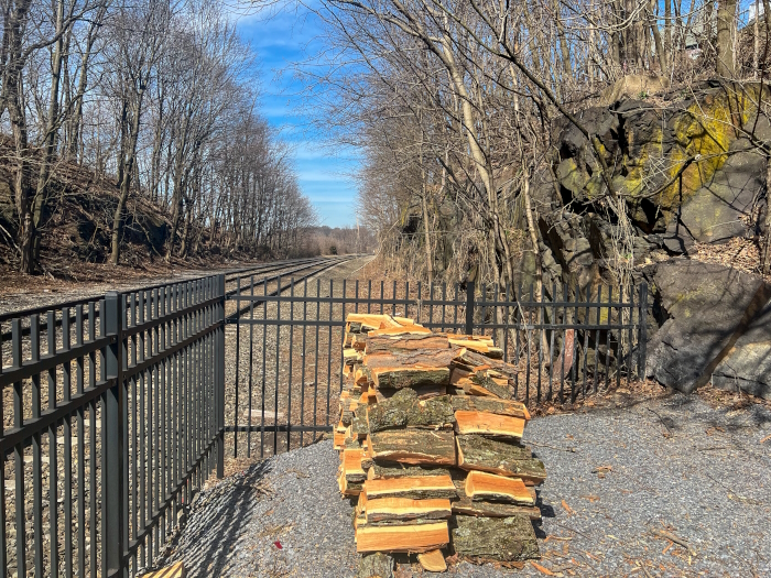
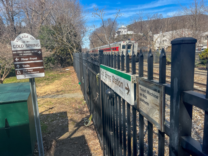
Plus, there’s now an alternative alternative path that came up for discussion and will be investigated by HHFT, New York State and Metro-North, among others. This route, briefly mentioned on March 11, would skip Dockside. Instead, it would hug the western side of the tracks from the train station to the village line.

It should not be confused with two proposed routes running along the east side of the tracks that were discarded but revived by village officials and two Philipstown members of HHFT’s data committee. They suggested the routes could be viable if Metro-North is flexible on its rule that the trail must be at least 25 feet from the center of the tracks.
During a March 14 tour of the alternative routes, Amy Kacala, the executive director of HHFT, said the organization tried to get Metro-North to discuss the setback and failed. “But maybe now that it’s municipal officials requesting it, they’ll look at it differently,” she said.
Even if Metro-North reconsidered its 25-foot setback, there are obstacles to mapping the trail on the east side of the tracks, she said. For one, it would probably displace the Depot Restaurant’s outdoor patio and involve blasting through a rocky outcrop that could damage the houses located there. “Not good,” Kacala said.
If the trail ran along the west side, it would pass through less private property and heavy rock blasting wouldn’t be needed, she said. It would serve as an extension of the path from the train station, which could be repaired and the fencing replaced. HHFT believes those prospective improvements might make Metro-North more amenable to waiving the setback requirements in certain spots, she said.
It’s not clear why the alternative route on the east side of the tracks, which was suggested by a Cold Spring resident, wasn’t part of the initial analysis done by SLR Consulting, although Kacala said private property close to the tracks may have been a deterrent. Regardless, the route is now undergoing the same analysis that the others went through. “These things don’t move very quickly, but we’ve started the ball rolling,” Kacala said.
At the March 11 meeting, SLR’s Michael Doherty explained how alternative routes are judged, such as maintaining a minimum 10-foot width (although 12 to 14 feet is preferred) and accounting for projected sea-level rise because of global warming.
He said each route was scored in 10 categories such as traffic and safety, congestion management, environmental stewardship, regional support and diversity of users. The route through Dockside had the highest score, with 44 of 50 points.
Fjord Trail in Beacon
The route along the east side of the tracks scored 27. A route up Main Street scored 24 in part because it would involve removing trees and parking spaces. If the trail went along the eastern side of Route 9D, it would have to ascend around Breakneck Ridge, because the state Department of Transportation says the trail cannot go through the tunnel.
That route scored a 20. The lowest score (18) went to placing the trail along Route 9D from Breakneck to Beacon, mostly because of private property lines and, in Doherty’s words, “low user safety.”
I have 0 confidence in the SLR scoring “method” of scenarios as being little more than the typical smoke HHFT is blowing and little foundation in science. Where is the “no trail from Cold Spring” option? The values reported for different options — whether 24 or 24,000, strike me as subjective and meaningless. Instead of allaying concern, they create alarm. The decision appears to be predicated on “the least invasive and abhorrent choice possible”: the least worst-case scenario, according to the one consultant. If all the choices are poor, the answer is clear: The idea was ill-conceived, and that will never change.
I don’t recall the provenance of the remarkably and alarmingly ill-conceived and inept idea to cut a “hobo trail” into the schist mountain along the tracks, but I pray it dies of its own impetus. Perhaps such cockamamie ideas merely serve to equivocate feasibility between hobo trails and a concrete swath and tourist theme park usurping Dockside. In that warped comparison, the latter then appearing to be more feasible, despite its vast shortcomings.
I also don’t recall hearing anyone from Cold Spring asking HHFT to interfere with our infrastructure and quality-of-life issues: a wolf in sheep’s clothing if ever there was. My recommendation is that the developers vacate their mega-tourist gentrification plan and leave Cold Spring in peace, and our problems in the hands of our capable mayor and Board of Trustees.
The deck provided by the developer for that meeting had the typical nebulous pros and cons, carefully and conveniently sifted and engineered to their liking. I have less than 0 confidence in the water table rise calculations based on speculations in the study, as if they had any idea.
In the west of Lunn Terrace meeting this past Saturday, residents voiced their concerns that were dutifully recorded on an easel but likely never progressed further than the dustbin. With each meeting I feel more worried that village concerns are not HHFT concerns unless HHFT pretends that they are.
I am 100 percent confident that Cold Spring deserves better than the least worst-case scenario, and the obvious choice — never considered by the developer — would be to end the trail at Little Stony Point, as was the original master plan before certain billionaires became involved, creating a proverbial HHFT monkey with a peanut machine. Ending the trail at LSP would erase all chaotic indecision and misguided “leadership” and the endless hype and spin we’ve been stewing in the past two years.
The trail south of LSP is a solution in search of a problem, ironically, problems stemming from the idea itself. Cold Spring has more pressing concerns than to accommodate an utter exacerbation and compounding of existing traffic and tourist loads, with buses, by-ways and bike-lanes. I strongly urge residents to continue to oppose mega-development in our micro-village, and leave us alone.
I am not opposed to the Fjord Trail — I am excited to use it. I grew up in Cold Spring, moved away for 20 years and moved back after working in the fields of architecture and urban planning in Taos, New Mexico, and Portland, Oregon. I bike and walk as preferred modes of transportation within the villages of Cold Spring and Nelsonville. I am a licensed architect, my wife is a licensed landscape architect. We own and operate an Architecture + Landscape Architecture firm in Cold Spring. I served on the Cold Spring Code Update committee which worked to rezone the riverfront parcels in question.
I want to have a conversation about the HHFT/Cold Spring interface in a non-adversarial way in order to discuss the amazing possibilities that the HHFT presents to improve rather than squander the resources presented by the two existing public riverfront public spaces and village sidewalk spaces which currently serve residents and visitors to this community.
I’m not saying “not in my backyard.” I’m saying — as a design professional who walks and bikes — “let’s get through my backyard in a way that makes sense and responds and respects existing public spaces and village infrastructure.”
Addressing real pedestrian and bike access to the Hudson Highlands Fjord Trail from the geographic center of Cold Spring Village rather than conveniently moving the start point of the trail to fit within the stated trail objectives is vital in terms of the ultimate success of the HHFT. Existing patterns of behavior, such as walking on Route 9D and Fair Street to access trailheads, cannot be solved by building a trailhead at Dockside — people have been shown to seek the shortest and most convenient route to Breakneck, even if it is not considered by professionals to be the “preferred” route. The HHFT has the possibility to be a real amenity for both people arriving by train or parking in a lot along 9D, as well as for residents of Cold Spring and Nelsonville who are looking for recreational opportunities along the river (and transportation alternatives to access Beacon and beyond).
At the HHFT presentation at the Dutchess Manor on March 11, Cold Spring village portions of the trail (Reach 1) were shown as full-width multi-use trails blazed through the center of the Village, obliterating street trees and sidewalks. Framing the design options in this way set the framework in place to automatically justify that the only place to blaze the trail through Cold Spring would be instead through the village’s most untrammeled portions: Dockside Park and between Mayor’s Park and the river, since it makes no sense to blaze a 10-foot trail along Fair Street or up Main Street.
Of course, given these parameters, it was easy to argue for a trail “terminus” at Dockside because it is relatively undeveloped and poses little in the way of physical barriers (other than requiring an over-water causeway). Rather than finding a nuanced solution that responds to the varied and complex character of an 18th-century village with 21st-century problems, HHFT opts for leaving crumbling pedestrian infrastructure “as is” and building in the one place that is easy to build because there is nothing built there yet. Is developing on and in front of our only collectively-owned undeveloped open spaces the only option? Or have the parameters merely been set up to make it seem like this is the only option?
I’ve annotated the map from the route analysis portion of the HHFT website. It is unclear to me why these various route options change the theoretical starting point for the trail and leave the most tragically un-walkable, un-bikable portion of the Main Street corridor, namely Lunn Terrace and Market Street, off the route-analysis matrix (and confusingly left as a dotted white line with no further analysis). By making the official start of the HHFT at Dockside and the unofficial start of the HHFT at the Metro-North station, HHFT effectively cuts off the populations of (and visitors to) Cold Spring and Nelsonville from the trail, with 100 percent preference given to visitors arriving by train or parking cars on lower Main Street and at the Metro-North parking lot.
For those unfamiliar with the area, here are some photos of the street conditions at Lunn Terrace and Market Street:
Lunn/Market:
Lunn Terrace Bridge:
Lunn Terrace:
HHFT is either consciously or unconsciously moving the start point of the Fjord Trail to different locations in order to modify the outcomes of their route analysis, thereby never addressing Lunn/Market directly, even though this is a vital point of connection between upper Main Street (and the population centers of Cold Spring and Nelsonville) and the proposed HHFT. Further, the route analysis gives no present value, either positive or negative, to the no-build option at Dockside, the Mayor’s Park viewshed and/or the no-build option which leaves Fair and Route 9D in their current dangerous state.
Given the fluidity of “start points” introduced by HHFT, I would like to posit, for the sake of argument, that a reasonable start point for both residents and visitors alike would be the intersection of Main Street (301) and Morris Avenue (9D). This is also a logical start point because newly implemented parking restrictions on Main Street in Cold Spring will likely push more visitor parking up into the residential streets East of 9D. With a fixed and logically determined start point, the route options in “Reach 1” could then be fairly compared.
With this simple change, the various routes presented by HHFT start to look much different. In addition, even with no change to the current trail “start point,” the HHFT “preferred route” should have to contend with the Lunn Terrace/Market Street conditions based upon the HHFT own presentations which rejected Morris and Fair due to restricted sidewalk constraints in the Village of Cold Spring.
As a community, what if rather than advocating for (or arguing about) one single access point, we looked at the cost of the over-water causeway being proposed between Dockside and Little Stony Point and looked at whether that could be divided into rational and reasonable improvements along Lunn/Market, Main, 9D and Fair Street as a combined “network” or “system” of co-existant path alternates, serving residents and visitors alike. The cost and benefit of this “network” approach could be compared to that of an elevated path over the river beginning at Dockside which obscures the majestic views of the mountains from Mayor’s Park.
Improvements to these Village streets and sidewalks, which could include sidewalk repairs and continuations as well as improvements to bike infrastructure (including but not limited to traffic calming, sharrows and “Share the Road” signage) could spread HHFT visitation out over a few routes rather than “funneling” it to one “preferred” route while providing ancillary benefits to residents and visitors alike.
Further, rather than looking at Dockside and Mayor’s Park merely as undeveloped areas with few constraints to the HHFT, shouldn’t they be afforded their own current value as important gathering points for both residents of and visitors to the Village of Cold Spring and Nelsonville? What are the weights given to the impact that the proposed route will have in perpetuity to the use and enjoyment of these two public resources? Building distributed trail infrastructure (i.e., sidewalk and bicycle safety improvements) within the confines of the existing transportation network in the Village of Cold Spring, Nelsonville and Philipstown is a worthwhile and challenging task — and could save (or improve) Dockside and Mayor’s Park as valuable amenities in and of themselves for residents and visitors while also providing safe and accessible access to Little Stony Point and beyond.
The large turnout was impressive, as was the expertise on display. It seems clear that the Fjord Trail is determined to listen to the community’s input and to address our concerns. The improved Breakneck train stop is already helping. Weekend hiker traffic seems to me at least to have diminished. A fully improved station with restrooms and other amenities will help even more.
The crowds will continue to come no matter what the community does — how to manage the crowds is the issue. The Fjord Trail people seem to have good ideas about how to do that. Continued community involvement in these discussions is more critical than ever.
I wanted to express my enthusiasm for the Fjord Trail and the presentation on March 11. Admittedly, I am close to and advocate the project. Still, the session provided a volume of info that everyone who attended can ponder when the state holds its meetings.
I was excited to see that there is still wiggle room on the starting point and that the ecology of the project is of paramount concern to all parties. The renderings made me incredibly hopeful of the beautiful possibilities. I live in the village and I’m familiar with the hordes of people who come on beautiful weather days. However, the claim by detractors that this is built for tourists seems myopic. The trail will be available seven days a week, even when it’s not perfect weather. As someone with arthritis in my knees, I look forward to being able to walk alongside the river and enjoy its majesty for many flat miles. I am eager for this to become reality.
I am pleased that HHFT is open to considering minor variations of access paths from the Metro-North station in Cold Spring to Little Stony Point. It’s a small concession to the needs of those who live here and a welcome change from the arrogant position that only starting in Dockside Park will do, and that HHFT and its army of prestigious, prize-winning experts know better than mere locals.
There is a saying that a successful negotiation is one from which all parties emerge equally unhappy. There is some truth to that. Everybody will have to give up something to create a broadly acceptable outcome. That’s better than some people giving up a lot so that others get a lot.
How will everyone get to the trail? Route 9, Route 9D and Route 301 are two-lane, curving roads with lots of traffic already. In the summer, with the Shakespeare Festival and the trail both happening on a Sunday afternoon, it will be like the Long Island Expressway during rush hour. [via Facebook]
In comments on this article, readers expressed concern that the criteria for assessing alternative routes for the Fjord Trail could bias a decision toward a terminus at Dockside Park.
Evidence for blatant criterion bias can be found on HHFT’s website in the video Reviewing Reach 1 & 2 – Dockside to Breakneck Ridge. The video presents slides that list pros and cons for each possible route. A “con” for every route that does not connect to Dockside Park is that it “does not connect to Dockside Park.”